Precipitation extremes – in terms of both excess and deficient rainfall – have caused serious disruption with widespread socio-economic impacts in many countries in recent weeks.
The World Metereological Organisation (WMO) sheds light on some of the high-impact events.

Asia
As a result of torrential monsoon rains, almost 41 million people have been affected by flooding and landslides in Bangladesh, India and Nepal. More than 1,200 people are reported to have died. Tens of thousands of houses, as well as schools and hospitals, have been destroyed leaving people displaced, according to the UN Office for the Coordination of Humanitarian Affairs.
In India, as of August 24, 32.1 million people have been affected by flooding across Assam, Bihar, Uttar Pradesh, and West Bengal. More than 600 people are known to have died. The India Meteorological Department issued an advisory on August 29 warning of very heavy rain over the next three days in parts of 12 states which were already hit by floods. India’s most populous city Mumbai was paralysed by flooding on August 29 to 31.
The cumulative seasonal rainfall from June 1 to August 30 shows that rainfall was normal in 24, in excess in six and deficient in six meteorological sub-divisions. The all-India cumulative value is for 683.6 mm, or 3% below the long-term average of 707.4 mm, according to the India Meteorological Department.
In Bangladesh, monsoon floods affected 32 districts in the northern, north eastern and central parts of the country, affecting more than eight million people. Almost 700,000 houses are damaged or destroyed. As a result of torrential monsoon rains, 35 of Nepal’s 75 districts have experienced severe flooding, affecting 1.7 million people. Almost 65,000 houses are destroyed and 460,000 people displaced, according to OCHA.
In Pakistan, the coastal metropolitan city of Karachi received 88 mm of rainfall on 31 August, compared to the monthly average of 60 mm, causing widespread flooding.
Tropical cyclone Hato brought high winds and rain to Hong Kong and Macau on 23 August, China, causing devastation in Macau in particular. The China Meteorological Administration on 1 September issued a warning of the season’s 16th typhoon expected to make landfall on Guandong coast.

Africa
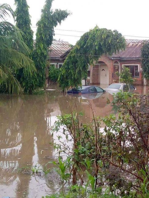
The total seasonal rainfall is above-average over most of the Sahelian region and West Africa. Torrential rains at the end of August caused already swollen rivers to burst their banks in a number of countries, including Nigeria and Niger. Dozens of casualties were reported in the worst floods since 2012.
Sierra Leone witnessed disastrous landslides near the capital Freetown. This followed a cumulative rainfall from August 1 through August 14, 2017 (1459.2mm) was over 300 percent of normal (normal rainfall for month of August is 791mm). During the period, significant rain ranging from 30 – 175mm fell continuously on a daily basis, with exceptionally heavy downpours from August 10 to 14 (daily minimum of 160mm). The cause of such continuous heavy downpour was attributed to uninterrupted influx of moisture into the coastal area coupled with strong convection in a super-saturated atmosphere.
At least 150 people are believed to have died in a landslide in a fishing village in Ituri province of the Democratic Republic of Congo from August 15 to 16.
Rainfall performance was generally normal in most of the Greater Horn of Africa region, according to the IGAD Climate Prediction and Applications Centre. “The rainfall condition in the Greater Horn of Africa region during the month of July 2017 continue to bring with it a relief in some of the areas especially in the northern sector and north-western sector of the GHA,” it said.
Rainfall less than 75% of the long term average was experienced in central and western Sudan; in much of Eritrea, Djibouti, north-eastern Ethiopia, Rwanda and Burundi; and in parts of north-western Somalia, south-western Uganda, central and eastern Kenya, and in eastern Tanzania.
North America
This year so far has been one of the warmest on record for the contiguous United States, with the January-July temperature ranking as the 2nd highest since records began in 1895. It has also been a wetter than average year (even before Hurricane Harvey), with the precipitation total for the first seven months of the year ranking as the seventh wettest in the 123-year record, according to the US National Oceanic and Atmospheric Administration.
Temperatures and precipitation have been above average. The Climate Extremes Index ranked as the third highest on record. There have been nine billion dollar weather disasters prior to Hurricane Harvey, which broke the record-long streak of a major hurricane not hitting the United States.
Hurricane Harvey
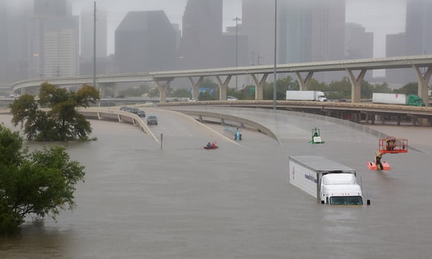
Unprecedented rainfall totals from tropical cyclone Harvey caused catastrophic flooding in southeastern Texas and southeastern Louisiana, leaving dozens of casualties, displacing thousands and causing huge economic disruption.
Large parts of southeast Texas saw more than 30-35 inches (762-889 mm) with isolated amounts up to 42 inches (1067 mm) of rain since August 24. Cedar Bayou in Texas received 51.88 inches of rain (1300 mm), according to the U.S. National Weather Prediction Center.
South America
In South America, the extreme rains experienced in the past months were supplanted by drought episodes in several countries during August. Moreover, winter rains have helped to alleviate drought conditions in the northern areas of South America. However, according to forecasters, there are concerns that a drier pattern will return to these areas during the spring, raising concerns about the drought conditions later in the season. This includes portions of Colombia, Venezuela, Guyana, Suriname, French Guiana and northern Brazil.
In Bolivia, the department of Tarija in the south of the country was affected by the drought in August. The Sama forest suffered severe fires causing death and property damage, while the Bolivian departments of Chuquisaca and Santa Cruz suffered cattle losses due to drought.
Forecasters report that dryness will not only lead to the risk of severe drought in other areas of South America, but also a greater threat of forest fires. Drier than normal conditions in eastern and central Brazil during the month of August are likely to lead to worsening drought conditions in the spring. The greatest threat will be for the Brazilian states of Paraná to the north. This dry climate during the spring could have an impact on several crops throughout the region, including coffee, soybeans and corn.
The southernmost areas in Brazil and Paraguay, Uruguay and northern Argentina have had adequate rains during the month of August and are expected to be slightly above normal for spring. This includes the Brazilian states of Rio Grande do Sul and Santa Catarina, as well as the capitals of Paraguay, Uruguay and Argentina.
According to CIIFEN, measurements and predictions of sea surface temperature for the period August-October 2017 indicate that the Central and Eastern Equatorial Pacific will be in neutral conditions, ie without anomalies. The evolution of the oceanic and atmospheric variables currently favors the establishment of neutral conditions in the Tropical Pacific, that is to say that at present the probabilities for El Niño and La Niña are low.
Europe
Parts of Italy and Southern France suffered severe drought, with the situation in Corsica reaching near record precipitation deficits. The rainfall deficit contributed to serious wildfires in southern France at the end of July. There were also devastating wildfires, with dozens of casualties in Portugal in June.
