What looks like a groundbreaking online map showing the migration paths of land animals around the world was on Wednesday, September 4, 2024, launched.
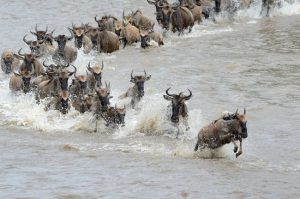
An international team of over 80 scientists has collaborated to create the first-ever interactive migration map of land hooved mammals such as antelopes, guanacos and zebras, that routinely travel large distances at different times in the year. Such animals are collectively called “ungulates”.
Known as the Atlas of Ungulate Migration, the tool uses the best available science to provide up-to-date migration maps. In addition to providing scientific information, the tool will be invaluable in informing conservation planning, infrastructure development, and policymaking to enhance ecological connectivity. The new interactive map currently covers 20 global populations, ranging from the iconic Serengeti wildebeest and African elephant, to the saiga of the Central Asian steppe.
Developed under the auspices of the Convention on the Conservation of Migratory Species of Wild Animals (CMS) – a biodiversity treaty of the United Nations – the researchers analysed tracking data to produce the new digital atlas. The online tool was developed through the efforts of the “Global Initiative for Ungulate Migration” (GIUM), established in 2020, representing a consortium of scientists and institutions worldwide. The maps will be made freely available to governments, conservationists, and the public.
“Knowing the routes used by animals for their migrations is essential to better understanding what we must do for their conservation and management. The Atlas will be a significant tool for policymakers to achieve their biodiversity objectives as well as addressing the needs of communities for development,” said Amy Fraenkel, CMS Executive Secretary.
Around the world, ungulates such as the Argentine guanacos, the Alpine ibex, and the Mongolian gazelles migrate across vast distances to find food, escape harsh weather, and raise their young. Ensuring their ability to migrate is vital for their survival. A variety of such animals provide benefits for human needs and national or local economies, from tourism, as a source of food, and through the transport of nutrients and other functions.
“This atlas represents a major milestone for conservation worldwide, and we believe the migration maps will be a tangible and effective tool to help stem the loss of the world’s ungulate migrations,” said Matthew Kauffman, a wildlife biologist with the U.S. Geological Survey (USGS) and the University of Wyoming, and a member of GIUM’s scientific advisory board.
At the CMS 14th Conference of the Parties (COP14) in February 2024, the United Nations released the first-ever State of the World’s Migratory Species Report, which found that 44% of migratory species listed under CMS are in decline, largely due to human activity.
As human populations grow and development expands, migratory ungulates face a myriad of threats. These include habitat fragmentation from fences, roads and railways, overexploitation from poaching, and climate change. These combined pressures are outpacing animals’ capacity to adapt and the conservation community’s ability to respond. GIUM’s work is timely, offering data that can help tackle these threats more effectively.
“We have reached an environmental tipping point where it’s more urgent than ever to have sound data to pinpoint exactly where to direct conservation efforts that can make the most impact for migratory wildlife,” said Grant Hopcraft, conservation ecologist with the University of Glasgow and member of GIUM’s scientific advisory board.
The Central Asian region, for instance, harbors the largest intact and still interconnected grasslands worldwide. But it has also seen a steady development with the expansion of infrastructure, including railways and new trade routes. The atlas shows how a railway construction impacts the Saiga Antelope’s movement, cutting them off from critical winter habitats. Researchers believe that by studying animal movements, solutions can be found that balance development with conservation.
When a migration has been mapped in detail, governments and stakeholders can prioritise wildlife-road crossings or other conservation measures that may ease the travels of migratory herds amid rapid global change. The CMS Central Asian Mammals Initiative (CAMI) provides a common framework to coordinate such conservation activities in the Central Asian region.
In North America and Europe, collaborative efforts are using corridor maps to target fences for modification or removal, site road-crossing structures, adjust energy development footprints, and focus conservation efforts on working lands. In the hands of authorities and conservation practitioners, the migration maps are key to finding on-the-ground solutions to keep these vital corridors open and functional amid ongoing development.
Moving forward, GIUM will be expanding the Atlas by adding more corridor maps for many migratory populations not yet represented. The collaboration of over 50 institutions worldwide aims to stimulate research on threats common to migratory ungulates and work with government and NGO partners to effectively utilise the available maps to promote wildlife conservation. GIUM is collaborating with Wildlife Conservation Society, the World Wildlife Fund and the World Bank, among others, to provide easy access to the maps and disseminate information on critical migration corridors to inform planning and policy.
The Atlas of Ungulate Migration launches at a time of growing international focus on preserving biodiversity and addressing ecological connectivity, a key component of the Kunming-Montreal Global Biodiversity Framework (KMGBF or Biodiversity Plan). The online maps are also a crucial contribution to the Global Partnership on Ecological Connectivity, launched at the CMS COP14 in 2024, as well as a broader CMS initiative to develop a global atlas of animal migration for all CMS-listed migratory species. Conserving migratory species such as ungulates also supports broader objectives, including the UN Sustainable Development Goals.
“We have recently demonstrated that some species are able to plastically adjust migration to environmental conditions,” says Francesca Cagnacci, GIUM advisory board member from Fondazione Edmund Mach in Italy. “But without space to move freely to compensate for these threats, migratory populations will decline, sending ripple effects through ecosystems and economies.”
“Understanding how animals respond to the types of mitigation options available, in addition to where animals are being blocked by fencing or railways, is important for restoring migrations severed by development,” says Nandintsetseg Dejid, wildlife ecologist with the Senckenberg Biodiversity and Climate Research Centre, Germany.
“Once these migration patterns have been mapped at the global and regional levels, it guides us at national level on the prioritization of key landscapes and on our policy and planning processes,” says Patience Gandiwa, CMS national focal point for Zimbabwe and Director for International Conservation Affairs at ZimParks. “These migration maps will therefore be very useful to Zimbabwe as we are already pursuing the wildlife conservation agenda beyond the protected and conserved areas.”